There was a time when our beautiful valley knew not the sounds brought by the white man. Quiet Indian villages were
joined by trails through tall grass. Wild flowers were abundant, and also wild animals. The river and streams offered
fine fishing. Huge oak trees dotted the landscape and acorns were plentiful.
The first white men to visit our valley that there is written report of was in 1826. Jedediah Smith and his little
band of hunters and explorers made their way through this unknown territory searching for a way to Oregon.
In 1843 General John Sutter dispatched Major Pierson Reading and General John Bidwell into the north valley on a
reconnaissance survey.
In 1844 General Bidwell, Peter Lassen, Albert Toomes, Job Dye, William Chard, Robert Thomes and William Moon came
to the area. General Bidwell named most of the streams in Tehama County and drew maps to take to Monterey for
the purpose of seeking land grants from the Mexican government. All except William Moon pledged allegiance to
Mexico and were granted the choicest land. Moon was last and since the "big six" had left little, he came back
and squatted on small holdings on the west side of the river in the vicinity of what came to be Squaw Hill.
Lassen's adobe was some three miles upstream from Moon's adobe, but his grant extended down the east side of
the river for some distance.
I know of no boundary for the Squaw Hill area but will give a short history of the important parts historically
speaking. The history of Squaw Hill is also the history of the Moon House, of two river boat landings on the
west side of the river, of Lassen's adobe, of later developments of the east side of the river.
Squaw Hill was named in the early days of the steamers. Two Indian ladies too feeble to return to the mountains in the spring with the rest of the tribe were left in a small shack at their camping site. They enjoyed watching the river boats and the river captains named the spot Squaw Hill.
Approximately two miles south of Squaw Hill, Moon built his adobe house and made plans for the future. He didn't foresee the gold rush, but he did foresee travelers and settlers coming into a land that held so much promise.
Soon a lumber mill was a going business at Weaverville, and Moon brought down lumber from there to start building the first frame house in the valley. It took two to three years to complete, but before it was ready travelers were happy to stay over night in the rough building. One of them was Goldsborough Bruff, author of The Gold Rush. Bruff kept meticulous records and we have learned much about the early days from his writing.
William Moon had an Indian village to the north of his new home. His adobe was south. His Indians ran a ferry at his place. The ferry could transport foot passengers, one wagon at a time, and also fortunate ones who had horses to ride.
Moon's place soon became a very important traveler's rest. A road followed the river up the valley and in 1851 a stage line was started. This road passed in front of Moon's. Some gold seekers came this far on the stage and took the ferry to the east side. A path or road of sorts led to the mountains, to the gold fields.
Traveler's rests were very important in those days. One we should mention here was about two miles west of Moon's place. This was run by a Mrs. Hall and her children. A daughter of hers was the bride in the first Tehama County marriage. Bruff's Gold Rush tells of this event.
It had been the custom of the Indians before the white man came to spend the winters in the valley along the river, fishing, hunting the plentiful wild game and gathering acorns. The Indians from the western mountains camped on the west side of the river. The Indians from the eastern mountains camped on the east side. Squaw Hill was a favorite place.
The river road followed the river closely at this point. Today the Gardiner Ferry Road follows the same path. At one time it was an Indian path.
As many people came, not everyone hunted gold. Small and large farms were developed. Produce could be shipped on the river boats and many landings were built.
An important landing was established a short distance north of Squaw Hill by the Sacramento Transfer Co. John Mc Lane, who owned a sizeable acreage of land, was named manager. In 1894 a large warehouse was built at the landing. Ranchers came from great distances to leave produce to be picked up. Some of the old river bank can still be seen in places.
As the river flows toward Squaw Hill a large bend brings it back to the original bed. Peter Lassen's adobe is no more, the Indian path down the east side is gone, but two beautiful parks have taken its place. The Tehama County River Park was made possible by the visions of few and the efforts of many, and through the kindness of John Saldubehere who purchased the land and held it until it could be developed.
The Woodson Bridge State Park to the east of the County Park draws large crowds of campers and fishermen throughout the year.
The Squaw Hill community established its first school on property given by William Mc Lane. Mc Lane owned 336 acres and donated one acre at the corner of Hall road and Loleta Ave. The first teacher for the first Moon School was a Mr. Hill.
That building served as the only school for miles around. The children walked, many barefoot, or if they were fortunate enough, rode horseback to school.
In time, a larger school was needed and a two-room school was built. It had an extra room on the back which was used for lunchroom and utility room. The school building was also used for a community hall. A sizeable Sunday School, a branch of the Corning Methodist Church, met in the schoolhouse for many years, with some 90 members in the report of 1907-1908.
In 1910 the Merrill School was built. It served the southern part of the area, very close to the original Moon holdings. The Moon School house is now a private dwelling, and the Merrill building is our Community hall.
Just as the river changed its course to the north of Squaw Hill, so we find as we go south that it has meandered far to the east at the Moon House's location. Beautiful walnut orchards can be seen on every side. It is approximately one mile to the river.
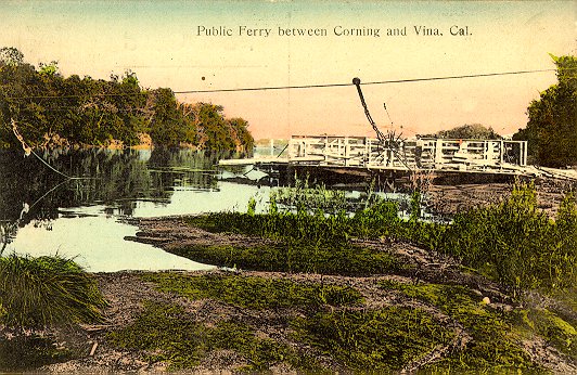
Many attempts were made to provide transportation across the river in the Squaw Hill area. Peter Lassen had a small ferry at one time. William Moon's Indians ran his ferry for many years. Others tried and failed. Sometimes high water carried them away, at other times cables were mysteriously cut. Eventually Chris Gardiner established a toll ferry at Squaw Hill and built his home on top of the hill overlooking the approach. The county later bought it and made it free.
The Stanford Ranch at Vina resisted having a road go through its property, but many vineyards were planted in the Corning area and the grapes were hauled to the Winery at Vina. Soon the road led from Vina and connected with other roads on the East side. It has been changed from those days and now runs straight to Highway 99E and is part of South Avenue.
Around the turn of the century, Mr. A.F. Landis purchased the property on Squaw Hill. He called it "River View Farm." One of the first olive orchards was planted here and is doing well today. He had various fruit trees and good pasture.
In 1944 the Edward Dietz family purchased the property. We found evidence of the many Indian campfires in the soil around the home. It was black and ashy.
Today River View Farm is no more, but Woodson Bridge Estates, a fine adult Mobile Park, is being developed. Squaw Hill will continue to be a cherished place for many people.
© 1996 David Louis Harter, California Technologies